![](/images/other/stat-length.png)
![Randonnée Marche La Hague - 50 Nez de Jobourg baie d'Ecalgrain 11km - Photo](https://media.geolcdn.com/t/1900/400/ea63df45-169f-41d1-8e4a-a0664d4d8e9b.jpg&format=pjpeg&maxdim=2)
50 Nez de Jobourg baie d'Ecalgrain 11km
SyMA
Utilisateur
![Longueur](/images/other/stat-length.png)
Longueur
10,9 km
![Altitude max](https://static1.geolcdn.com/siteimages/upload/files/1508320355ic_sort_altitude_max_24dp.png)
Altitude max
128 m
![Dénivelé positif](https://static1.geolcdn.com/siteimages/upload/files/1508320355ic_sort_den_pos_24dp.png)
Dénivelé positif
326 m
![Km-Effort](/images/other/stat-length.png)
Km-Effort
15,2 km
![Altitude min](https://static1.geolcdn.com/siteimages/upload/files/1508320355ic_sort_altitude_min_24dp.png)
Altitude min
5 m
![Dénivelé négatif](https://static1.geolcdn.com/siteimages/upload/files/1508320355ic_sort_den_neg_24dp.png)
Dénivelé négatif
323 m
![Boucle](https://static1.geolcdn.com/siteimages/upload/files/16400158638029165_repeat_loop_refresh_sync_direction_icon.png)
Boucle
Oui
Date de création :
2020-07-17 07:57:14.465
Dernière modification :
2020-07-17 17:27:01.323
![Marche](https://static1.geolcdn.com/sitytour/trail-icons/101.png)
4h01
Difficulté : Facile
![Scannez ce code QR pour ouvrir la randonnée dans l'application SityTrail](https://capi.geolives.com/qq0zvz2zws4bq2lad0pu/sitytour/trails/2479115/qr.png?size=200)
Application GPS de randonnée GRATUITE
À propos
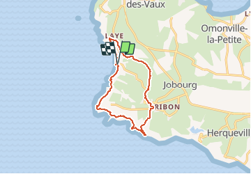
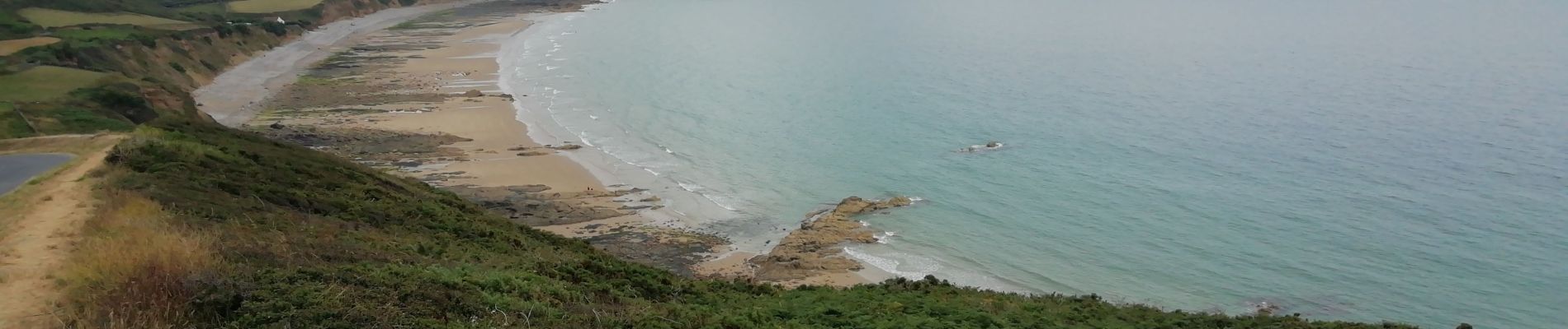
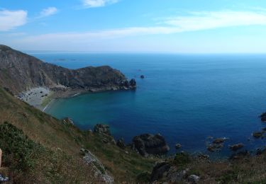
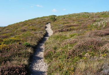
Randonnée Marche de 10,9 km à découvrir à Normandie, Manche, La Hague. Cette randonnée est proposée par SyMA.
Description
Depart de parking de Baie D'Ecalgrain
Belle rando en bord de Manche avec belles vues et retour par les terres
Point pique nique au hameau Dannery
Localisation
Pays :
France
Région :
Normandie
Département/Province :
Manche
Commune :
La Hague
Localité :
Auderville
Départ:(Dec)
Départ:(UTM)
576822 ; 5504750 (30U) N.
Commentaires
Randonnées à proximité
![Randonnée Marche La Hague - NEZ JOBOURG - Photo](https://media.geolcdn.com/t/375/260/c98676c9-55e7-4381-9b91-05c742077aaf.jpg&format=jpg&maxdim=2)
![Marche Marche](https://static1.geolcdn.com/sitytour/trail-icons/101.png)
NEZ JOBOURG
Marche
Difficile
(2)
La Hague,
Normandie,
Manche,
France
![](/images/other/stat-length.png)
21 km | 27 km-effort
5h 48min
![](https://static1.geolcdn.com/siteimages/upload/files/16400158638029165_repeat_loop_refresh_sync_direction_icon.png)
Oui
![Randonnée V.T.T. La Hague - Le Tour des Echoués - Jobourg - Photo](https://media.geolcdn.com/t/375/260/ext.jpg?maxdim=2&url=https%3A%2F%2Fservices.sitytrail.com%2FGeolivesWS%2FDownloadMedia.ashx%3FTrailID%3D173186%26Media%3D14770_5.jpg)
![V.T.T. V.T.T.](https://static1.geolcdn.com/sitytour/trail-icons/202.png)
Le Tour des Echoués - Jobourg
V.T.T.
Moyen
(1)
La Hague,
Normandie,
Manche,
France
![](/images/other/stat-length.png)
26 km | 32 km-effort
2h 0min
![](https://static1.geolcdn.com/siteimages/upload/files/16400158638029165_repeat_loop_refresh_sync_direction_icon.png)
Oui
![Randonnée Marche La Hague - Ecalgrain et sa baie. - Photo](https://media.geolcdn.com/t/375/260/ext.jpg?maxdim=2&url=https%3A%2F%2Fservices.sitytrail.com%2FGeolivesWS%2FDownloadMedia.ashx%3FTrailID%3D102758%26Media%3D3900_6.jpg)
![Marche Marche](https://static1.geolcdn.com/sitytour/trail-icons/101.png)
Ecalgrain et sa baie.
Marche
Difficile
(4)
La Hague,
Normandie,
Manche,
France
![](/images/other/stat-length.png)
13,4 km | 18,3 km-effort
3h 15min
![](https://static1.geolcdn.com/siteimages/upload/files/16400158638029165_repeat_loop_refresh_sync_direction_icon.png)
Oui
![Randonnée A pied La Hague - Séjour Cotentin Etape 3 Nez de Jobourg - Biville - Photo](https://media.geolcdn.com/t/375/260/0edaec19-e94e-4149-8092-0ff358c3dd07.jpg&format=jpg&maxdim=2)
![A pied A pied](https://static1.geolcdn.com/sitytour/trail-icons/100.png)
Séjour Cotentin Etape 3 Nez de Jobourg - Biville
A pied
Difficile
La Hague,
Normandie,
Manche,
France
![](/images/other/stat-length.png)
23 km | 33 km-effort
7h 30min
![](https://static1.geolcdn.com/siteimages/upload/files/16400158638029165_repeat_loop_refresh_sync_direction_icon.png)
Non
![Randonnée Marche La Hague - Séjour Cotentin Etape 3 Le nez de Jobourg et Biville a corriger - Photo](https://media.geolcdn.com/t/375/260/769074c5-2128-40cd-af27-847ab7c0e7c4.jpg&format=jpg&maxdim=2)
![Marche Marche](https://static1.geolcdn.com/sitytour/trail-icons/101.png)
Séjour Cotentin Etape 3 Le nez de Jobourg et Biville a corriger
Marche
Très difficile
La Hague,
Normandie,
Manche,
France
![](/images/other/stat-length.png)
23 km | 33 km-effort
7h 31min
![](https://static1.geolcdn.com/siteimages/upload/files/16400158638029165_repeat_loop_refresh_sync_direction_icon.png)
Non
![Randonnée A pied La Hague - Séjour Cotentin Etape 2 Boucle Jobourg La Hague - Port Racine - Omonville la petite - Photo](https://media.geolcdn.com/t/375/260/c0e0de9e-3bd4-4319-af5c-c6b5aff35ffd.jpg&format=jpg&maxdim=2)
![A pied A pied](https://static1.geolcdn.com/sitytour/trail-icons/100.png)
Séjour Cotentin Etape 2 Boucle Jobourg La Hague - Port Racine - Omonville la ...
A pied
Difficile
La Hague,
Normandie,
Manche,
France
![](/images/other/stat-length.png)
28 km | 34 km-effort
7h 44min
![](https://static1.geolcdn.com/siteimages/upload/files/16400158638029165_repeat_loop_refresh_sync_direction_icon.png)
Oui
![Randonnée Marche La Hague - goury / vauville - Photo](https://media.geolcdn.com/t/375/260/ext.jpg?maxdim=2&url=https%3A%2F%2Fstatic1.geolcdn.com%2Fsiteimages%2Fupload%2Ffiles%2F1553511878bg_sport_marche.png)
![Marche Marche](https://static1.geolcdn.com/sitytour/trail-icons/101.png)
goury / vauville
Marche
Difficile
(1)
La Hague,
Normandie,
Manche,
France
![](/images/other/stat-length.png)
16,5 km | 24 km-effort
5h 17min
![](https://static1.geolcdn.com/siteimages/upload/files/16400158638029165_repeat_loop_refresh_sync_direction_icon.png)
Non
![Randonnée Marche La Hague - Magiquement votre - Photo](https://media.geolcdn.com/t/375/260/c49fffc8-7c79-42cf-a4d6-b3c2cf7eec90.jpg&format=jpg&maxdim=2)
![Marche Marche](https://static1.geolcdn.com/sitytour/trail-icons/101.png)
Magiquement votre
Marche
Moyen
La Hague,
Normandie,
Manche,
France
![](/images/other/stat-length.png)
25 km | 33 km-effort
6h 12min
![](https://static1.geolcdn.com/siteimages/upload/files/16400158638029165_repeat_loop_refresh_sync_direction_icon.png)
Oui
![Randonnée Marche La Hague - Boucle St-Germain-des-Vaux - Auderville - La Roche - Goury - Photo](https://media.geolcdn.com/t/375/260/e5808f0a-2966-4fdc-bdca-55912ac6256a.jpg&format=jpg&maxdim=2)
![Marche Marche](https://static1.geolcdn.com/sitytour/trail-icons/101.png)
Boucle St-Germain-des-Vaux - Auderville - La Roche - Goury
Marche
Facile
La Hague,
Normandie,
Manche,
France
![](/images/other/stat-length.png)
12,4 km | 14,7 km-effort
5h 22min
![](https://static1.geolcdn.com/siteimages/upload/files/16400158638029165_repeat_loop_refresh_sync_direction_icon.png)
Oui